Why a Tidal Edge Changes the Shape of a Waterfront
A tidal edge changes how a waterfront meets the city: learn why steps, slopes and working margins suit different shorelines and daily uses.
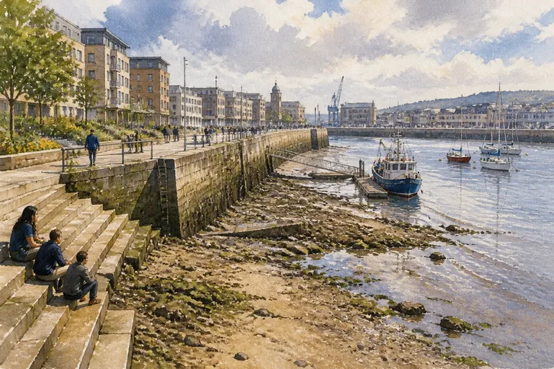
A tidal edge changes the shape of a waterfront because the waterline does not stay put. At high tide, a wall may meet the water; hours later, the same wall can stand above exposed stones or mud. That daily shift affects where people can walk, where boats can settle, and how a city makes room for the shore.
The useful question is not simply whether a waterfront has a wall, steps or a sloping bank. It is how that form behaves as the water rises and falls, and what relationship the city wants with the changing strip between land and water. A tidal edge is a kind of moving boundary, like a sliding door: the opening changes, but the room on either side still has to work.
The moving waterline
At high water, the sea reaches furthest inland. As the tide falls, it uncovers more of the shore; as it returns, that ground is covered again. The exact reach and pace differ from place to place, and wind, waves, river flow and the shape of the seabed can all affect what a visitor sees.
For waterfront design, this means the land-water boundary is a band, not a single line. A quay can have a fixed top edge while its lower face alternates between submerged and exposed. On a low-lying shore, the water may spread across a broad, gently sloping area. In a harbour, the tide can change the height at which a moored boat sits beside a landing.
People often notice the change through ordinary cues: a boat’s lines slacken or tighten, a wet mark appears on stone, or a familiar stretch of shore becomes inaccessible beneath water. These visible signs matter because a waterfront is used at particular moments, not as an abstract drawing. A design that works at one water level may be awkward at another.
Walls and vertical edges
A vertical quay wall holds a clear line between city and water. It can make valuable ground usable close to a deep channel, provide a firm face for boats, and support cargo or service activity where access from land needs to meet vessels. The top of the wall remains a legible route even as the water level changes below it.
But the vertical form concentrates the difference in height. At low tide, the water may drop away from the quay, leaving a substantial gap between the surface and a boat’s deck or a landing point. A fixed ladder, floating pontoon or adjustable gangway may address a particular access need, but each works only within its intended setting. The choice depends on the vessels, shore conditions and public or operational use.
A wall can also leave little room for the changing intertidal zone—the ground that is covered at high water and exposed at low water. Where that habitat or a more gradual contact with the shore is a priority, a hard vertical edge may not fit the aim. The trade-off is not simply hard versus soft: a working quay and a habitat-rich foreshore serve different purposes, and a waterfront may need to accommodate both in separate places.
Steps, slopes and ledges
Steps create several small platforms at different heights. As the tide changes, some treads may be wet while others stay dry, offering people a closer encounter with the water without making the whole edge one steep drop. Broad steps can also give a waterfront a place to pause, watch boats or sit near the shore.
The same form asks for careful attention to use. Wet stone can be slippery, and a lower tread may disappear beneath the tide. Steps do not automatically provide a suitable route for everyone, so a continuous accessible path at a dependable level may be needed alongside them. Clear sightlines and visible changes in water level help people understand which parts are available at a given time.
A sloping bank spreads the change in water level across more ground. It can support a gradual transition between city and shore, with planted margins or a rougher intertidal surface. Yet a slope occupies more horizontal space than a wall, and repeated waves can reshape loose material. In a constrained harbour, that land demand may be difficult to reconcile with roads, buildings or working access.
Ledges and terraces can combine some of these qualities. A broad upper route might sit above the usual reach of the tide, while lower shelves offer places for water to meet stone or for people to approach under suitable conditions. Their usefulness depends on how often they are submerged, how they drain, and whether the lower levels have a clear purpose rather than being leftover space.
Matching form to use
The right edge starts with the activity it must support. A fishing landing needs a dependable way to bring people, gear and small craft together. A busy quay needs clear working space and a robust face. A public waterfront may value places to sit, routes that remain open, and a visible connection to the water. A habitat-focused shore may need room for plants, sediment and changing water rather than a continuous hard boundary.
These needs can overlap, but they do not always fit at the same point. A city might keep a vertical edge where vessels need close access and use a sloped or stepped form elsewhere. Transitions between forms deserve attention too: a change from wall to bank can create awkward corners, trapped debris or a break in a walking route if it is treated as a line on a plan rather than a place people use.
Say a neighbourhood has a broad, shallow shore beside a public path, and residents want to see the changing tide without losing a continuous route. A designer might keep the main path on higher ground, then shape a lower planted margin that is allowed to flood and dry. The expected observable result would be a path that remains distinct from the shifting waterline, alongside a shore whose exposed and submerged parts change through the day. This imagined example shows why the edge and the route need not occupy the same level.
Materials also influence how a form meets the tide. Rough stone, concrete, timber and planted soil weather differently under salt, water and wave action. A finish that is comfortable underfoot at the top may become slick below the usual waterline, while exposed joints or loose elements may need maintenance suited to the site. Local conditions and the intended use should guide material choices rather than appearance alone.
Reading the whole tide range
Thinking only about high water can hide the lower shore; thinking only about low water can make the waterfront seem less connected than it is. A useful design view considers the changing span: where water reaches, what is exposed, which routes remain usable, and how boats or other activities relate to the edge at each stage.
That view also includes the everyday timetable of the city. A landing might be busy when a particular water level allows a vessel to reach it. A waterside seat may be attractive when the lower stones are dry, but unavailable when waves wash over them. A route beside a tidal channel may need a clearly separate, reliably passable line rather than relying on the exposed shore as a shortcut.
For a visitor, small details make the arrangement easier to read. Tide marks show recent reach; steps reveal which levels are intended for approach; railings or changes in paving can distinguish the public path from a working area. These cues do not replace sensible local guidance, but they help make a changing edge understandable rather than surprising.
Questions about tidal edges?
Why does the shoreline look wider at low tide?
Falling water exposes ground that was covered at high tide, so the visible shore extends farther from the landward edge. On a shallow slope, a modest change in water level can uncover a broad strip.
Are steps better than a quay wall?
Steps can create several approach levels and places to pause, while a wall keeps a sharper boundary and may suit working access. Neither is automatically better; the choice depends on water conditions, available space and how the waterfront is meant to be used.
Can a waterfront have both public access and working space?
Often, different sections can serve different functions, with a clear route separated from areas used for boats or operations. The layout needs to make boundaries visible and avoid sending visitors through active work zones.
What should a visitor notice first?
Look for the waterline, exposed steps or shore material, and the route that stays above the changing edge. Together, these details show how the waterfront accommodates the tide and where people are expected to move.
A boundary that keeps moving
A tidal edge is not just the border of a map; it is a space whose shape and availability change during the day. Walls, steps, slopes and terraces each manage that movement differently, shaping the relationship between boats, public routes, working areas and the exposed shore.
When you next walk beside a tidal waterfront, compare the line where the water sits with the places built for people to stand or pass. The gap between them often explains the design: where a city chooses to meet the shore closely, where it gives the tide room, and which parts are meant to keep working as the water moves.