Before the Marina: How Harbours Gathered City Life
Before the marina, harbours gathered city life through trade, repair and shared routes. Learn to read surviving clues and interpret waterfront change with care.
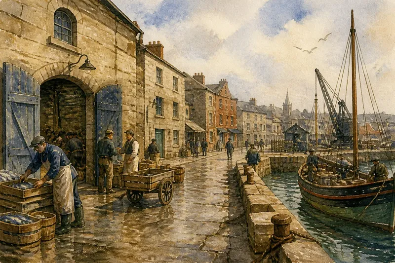
Before the marina, harbours gathered city life around the work of moving goods, repairing boats and meeting people from elsewhere. You can still read that older purpose in a waterfront’s street pattern, buildings and surviving working spaces, even where leisure is now more visible. The clues rarely tell a simple story: harbours changed at different speeds, and many still serve several purposes at once.
That complexity can make a visit confusing. A broad quay may look like a public square but serve a working operation; a handsome warehouse may hint at trade without explaining who could enter it. To understand how a harbour shaped its city, look at the practical connections between the water, nearby streets and everyday work.
Reading Harbour Traces
Why does the old harbour feel disconnected from the city?
Harbour streets were often shaped by cargo, storage and access to vessels, not by a visitor’s desire for a direct route. Later roads, rail lines or redevelopment may have cut across those connections, leaving a surviving quay or warehouse separated from the neighbourhood that once depended on it.
Look for links rather than a single landmark. Notice whether narrow streets lead towards former loading areas, whether a market sits close to an old route, and where rail sidings or broad service roads meet the water. A map can help, but the ground-level pattern matters too: a blocked passage or abrupt change in paving may mark where an old connection was interrupted.
How can a building’s old use be recognised?
A large, plain storehouse can be mistaken for a factory or a later commercial building. Look for practical features together: wide doors facing the quay, sturdy ground-floor openings, loading bays, upper floors suited to storage, or a position close to a former dock entrance.
One clue is not enough to identify a building’s history. Its present use may have changed, and later alterations can disguise earlier details. Read the building alongside nearby streets and harbour structures instead of treating its appearance as a label.
Why does a public-looking quay have limited access?
Some waterfront edges remain tied to vessel movements, cargo handling, maintenance or security. A generous paved surface does not necessarily mean people can walk across it freely; a boundary may reflect an active operation rather than an attempt to exclude visitors from a finished public space.
Follow posted access signs and use designated routes. From a permitted viewpoint, you can still observe how the working edge meets roads, sheds and mooring areas. The distinction between a public route and operational ground is part of the harbour’s present character.
Why do old harbour landmarks tell conflicting stories?
Harbours served different groups, and not everyone experienced them in the same way. A customs building might represent the regulation of trade to one person and a barrier to another; a surviving market hall may recall both everyday livelihoods and limits on who could profit from them.
Look for several kinds of evidence: street names, building functions, old maps on public displays, and what remains in active use. If the clues do not settle into one neat account, that may reflect real changes in ownership and work rather than a gap you need to smooth over.
Work Before Leisure
An older harbour was more than a collection of docks: it organised work and movement across the city. Goods arriving by water needed storage, inspection, repair and onward transport. Those jobs drew workshops, shops, markets and homes close to the shore.
A lane behind the quay might connect a warehouse to a market; a nearby yard might supply rope or repair equipment; a public house might serve people finishing a shift. The pattern differed from place to place, but its effects were visible in repeated routes and meeting points. Like the spokes of a wheel meeting at its hub, these everyday connections brought separate parts of city life together around the waterfront.
Imagine a fictional port with a fish market beside the quay. Its boats have moved to another part of the harbour, but the market building, wide entrance and service lane remain. You observe that the lane still leads directly from the quay to the market door, while the former loading area is now separated from the water by a fence. The likely result is a clear distinction between the surviving route’s historical role and its present use: the market entrance and lane suggest how fish once travelled from landing to sale, while the fence shows that the old working connection no longer functions in the same way. Those clues support a focused question about the journey between arrival and sale, but they do not establish what every trader or worker experienced.
Change Without One Template
As trade and transport shifted, some harbours lost much of their original work. Elsewhere, cargo operations moved to another part of the same port while repair, fishing or passenger services continued. Some waterfronts added cafés, housing, museums or leisure moorings alongside working uses; others remained primarily industrial.
“Before the marina” is not a universal sequence in which every working harbour became a leisure destination. A marina is one possible later use, not an inevitable endpoint. Even within one city, a public-facing stretch may sit beside a restricted working zone, with older routes and buildings serving new roles.
When interpreting change, ask what moved, what stayed and who can use the place now. A converted storehouse may keep its waterfront position while losing its storage function; a service road may still serve boats even if new homes line the other side. Those details distinguish a description of change from an assumption that all former work has vanished.
Harbour History Questions?
What clues show a harbour shaped nearby streets?
Look for lanes that connect the quay to markets, warehouses or former transport routes, along with service roads that meet the water. These connections can suggest how people and goods moved, though a map or local heritage display may be needed to confirm their earlier purpose.
Can a warehouse reveal what it stored?
Wide quay-facing doors, loading bays and a position near a dock can point to storage or cargo handling. They cannot identify the goods by themselves, so describe the visible features unless a reliable local source supports a more specific account.
Why might a quay be closed to visitors?
It may still be used for vessel movements, cargo, repairs or security. Follow signs and observe from an authorised public route rather than assuming that open paving is public space.
Did every working harbour become a marina?
No: later uses differ, and some ports retain fishing, repair, passenger or industrial work alongside public access. Look at what is active on the particular waterfront rather than treating one city’s changes as a template.
Following the Evidence
A useful harbour walk does not require access to every quay. Start from a public street near the water and trace the sequence connecting city and shore: market, warehouse, transport route, loading edge. Then compare it with the present scene. Are boats still being serviced? Do deliveries enter from the same direction? Has a former route become a path or been closed?
Keep observations distinct from guesses. “Large doors face the quay” is visible; “the building stored imported grain” needs supporting evidence. A local heritage display, building notice or municipal map may help. If none is available, describe the clue without claiming certainty.
Before the marina, harbours gathered city life through repeated practical encounters, not one fixed plan. Follow the routes between water, work and surrounding streets, then notice which connections remain. The surviving lane or warehouse can help you ask sharper questions, while a missing link may be just as revealing about how the waterfront is used now.